Map Adoption Process
The Federal Emergency Management Agency (FEMA) is inviting the community to participate in a 90-day appeal and comment period regarding its proposed updates to the Flood Insurance Rate Map (FIRM) for Morris County, New Jersey – updates that could impact the use of properties near the special flood hazard area (SFHA).
The appeal and comment period began Sept. 25, 2026, and is the latest step in a flood mapping process that has been underway for several years. Residents, business owners and other community partners are encouraged to review the revised preliminary flood maps to better understand local flood risks and potential future flood insurance requirements. The data can be downloaded from the FEMA Map Service Center, or viewed through FEMA's data viewer.
Scientific Resolution Panel (SRP) municipalities' maps were on a separate track than these 36 municipalities. FEMA has finished generating new flood maps for those three (3) municipalities (Lincoln Park, Montville and Pequannock). The maps and data are effective as of August 19, 2025. The maps and data can be found here: https://msc.fema.gov/portal/advanceSearch.
FEMA’S map adoption process typically takes between 18-24 months. Please review FEMA’s brochure, "Map Adoption Process," for more details.
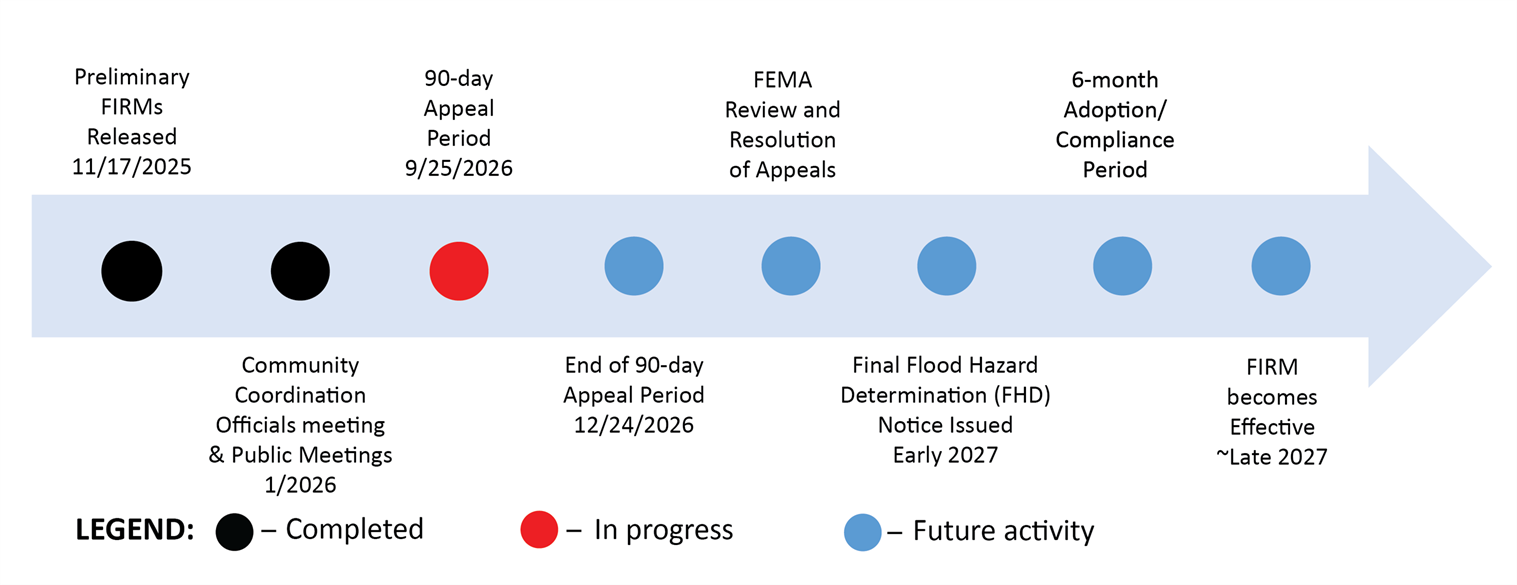
Please note: Other than the 90-day Appeal Period, and 6-Month Adoption/Compliance Period, there are no specific timeframes for the steps in the timeline below.
FEMA/NJDEP Partial County-wide FIRM Timeline
Map Finalization/Adoption
After the 90-day Appeals Period has ended, and all appeals have been resolved, FEMA will finalize the maps. A final Flood Hazard Determination (FHD) letter is sent to community officials which initiates a 6-month period during which the community must adopt the new FIRM to be in compliance. The FIRM will then become effective (adopted) and serve as the basis for flood insurance rates and purchase requirements, and local building regulations. Learn more about this process in FEMA’s publication, Adoption of Flood Insurance Rate Maps by Participating Communities.
If you believe your property has been incorrectly included in the Special Flood Hazard, after the FIRM and FIS are adopted, FEMA offers the Letter of Map Amendment (LOMA) Process.
Previously issued Letters of Map Change (LOMC) undergo a validation process as compared to the new FIRM. If still valid, they are listed on the community’s Revalidation Letter. This letter goes into effect one day after the new FIRM’s effective date.